Sunday, October 30, 2022
The purview and ambit of the State of Pakistan
Thursday, May 26, 2022
There is nothing exceptional about Kashmir!
There is nothing exceptional about Kashmir. There were princely states in the length and breadth of India from Makran or Kharan in the western province of Baluchistan in western India to Manipur in eastern India or from Gilgit and Kanjut in Kashmir in northern India to Thiruvithamkoor in southern India. The option of independence was not available to any of the princely states. What is exceptional about Kashmir alone? The so-called Kashmir issue is a freak and artificial one which is the result of the arbitrary and artificial partition of India and the callousness of Mr Jawaharlal Nehru and his wilful inaction regarding the enforcement of the accession of the princely state of Kashmir to the Union of India and rather lodging a foolish complaint in the United Nations Organisation without the prior eviction of the invaders or raiders from Pakistan. Nor did Kashmir become a condominium! Mr.Jawaharlal Nehru should have either permitted Pakistan to integrate the whole of predominantly Muslim Kashmir in its entirety into Pakistan, or he should have enforced the perfectly legal and valid legal accession of the whole of the princely state of Kashmir which comprises inter alia Gilgit, Kanjut, Baltistan, Ladakh, Mirpur, Chilas, the valley of Kashmir and Jammu in its entirety to the Union of India. But, Mr. Jawaharlal Nehru being Mr. Jawaharlal Nehru did neither! Even if the either had been done, then again there is a problem. It verily needed a vast strong united India with all the full strength which she could command to protect the external northern frontier of a geo-strategic province like Kashmir with the Trans- Kuen Lun Range country
of East Turkistan annexed by the Chinese. Neither the Pakistanis nor the Indians of the post 1947 partition moth-eaten India could do it on their own simply because only a big strong united country could do it! It was to circumvent this handicap or impediment that President Field Marshal Ayub Khan suggested a military alliance in the nature of a Common Joint defence for both India and Pakistan in the year 1959. The partition of India itself was intrinsically and inherently flawed and morally wrong as the Sub-continent of India is a single organic living entity which cannot be amputated or divided or partitioned into two distinct beings or entities! Thus the so-called Kashmir issue was created, but it had nothing whatsoever to do with the fact that intrinsically or inherently Kashmir is a part of India just like any other part of India. Nothing more, nothing less! By India, I mean the historical nation of India prior to 1947 of which Kashmir or Baluchistan are an organic part, and not the moth-eaten present artificial borders like the Durand or Radcliffe Lines after the 1947 partition. The reason for the so-called Kashmir issue is thus per se extraneous and has nothing whatsoever to do with intrinsic status of the province of Kashmir itself. Article 370 of the Constitution of India is no artificial gum or glue which will indefinitely and permanently bond two mutually distinct & incompatible items. It was never ever required. Either Kashmir is intrinsically & inherently a part of India which Kashmir per se is and Kashmir will remain an inalienable and sacred part of India without the requirement of an artificial glue or an adhesive or conversely, if a territory is per se incompatible and not intrinsically and inherently a part of India, no artificial glue or adhesive in the nature of Article 370 of the Constitution of India can retain the territory with the rest of India and the area would simply be a possession or colony rather than an organic part of India which Kashmir per se inherently and intrinsically is! Ultimately, the issue is whether the right to the nationhood of India can be permitted to be challenged and India be subjected to Balkanisation by whosoever or the nationhood of India be vindicated and whether the idea of India has to be preserved and protected for posterity!
Friday, April 1, 2022
India is destined to remain friend-less and alone
The United States Deputy National Security Advisor, Daleep Singh is absolutely right that come-what-may,
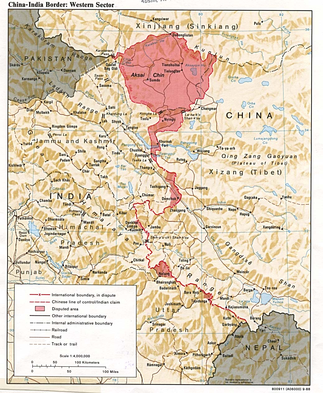
the Russians would only support the Chinese in their territorial claims in India including the Cis-Kuen Tract in northern Kashmir extending from Chhogori K2 to the Taghdumbash Pamir and Mariom Pamir and the Kukalang, Yangi, Kilian, Sanju-la and Hindu-tash Passes in northern Kashmir, or Aksai Chin 36°40'36"N 78°21'33"E in Ladakh. The issue is
whether the United States is going to unconditionally and absolutely support the territorial integrity and sovereignty of India vis-à-vis India's beloved and sacred inalienable Aksai Chin 36°40'36"N 78°21'33"E in Ladakh and whether their official and government maps would depict Aksai Chin in Ladakh as per se an integral and inalienable part of India and not a so-called disputed territory, in exchange for India's friendship and support! The answer is a big resounding no! The United States regime would also support the Chinese in their territorial claims inside India in particular Aksai Chin in Ladakh, not because Aksai Chin is allegedly a so-called disputed territory, but because of their ulterior vested interests and diabolical game-plan. Aksai Chin is per se a part of Ladakh and status of Aksai Chin as integral part of India is non-compromisable. The fact is that India has no friends and India is all alone and destined to be alone and friendless, and has to be strong and powerful, for her defence or offence, to on her own drive away and throw the Chinese out of India's beloved and sacred inalienable Aksai Chin 36°40'36"N 78°21'33"E in Ladakh and the Cis-Kuen Tract in northern Kashmir in the inevitable and impending war with the Rogue Chinese regime, and also to defend herself from threats to her
sovereignty and territorial integrity from the Russians and Americans vis-à-vis the Chagos Archipelago in Lakshadvipa 6°40'07"S 71°19'48"E in southeastern India. But the fact of the matter is that whichever government is in power in India, be it the Congress Government or the BJP government, the government of India is meek, submissive, subservient and servile and the
people of India rather than becoming modern, secular, irreligious and progressive nationalists are with the tacit support of the present dispensation gradually undergoing a metamorphosis and predominantly fast being converted to become perverse narrow-minded communal and fascists nurturing a visceral Islamophobia which imperils and threatens the predominantly peaceful Indian Muslims with genocide and annihilation!
Tuesday, January 4, 2022
Two ab initio illegal unilateral and arbitrary actions in 1954 in India and the Russian Federation respectively which resulted in the per se illegal diminution of the territorial extent of India and the Russian Federation, and how the two states responded to the illegality in the long run
In the year 1954 there were two momentous arbitrary and unilateral decisions taken which are per se ab initio illegal and null and void and non est in law which resulted in the per se illegal diminution of the territorial extent of the Republic of India, as well as the Russian Federation.
On April 26, 1954 There was a decree of the Presidium of the USSR Supreme Soviet transferring the Crimea Oblast from the Russian Soviet Federative Socialist Republic to the Ukrainian Soviet Socialist Republic.
According to a 2009 article on Russian website “Pravda”, the Presidium of the Supreme Council gathered for a session on 19 February 1954 when only 13 of 27 members were present. There was no quorum, but the decision was adopted unanimously.
The transfer merited only a paragraph in Pravda, the official Soviet newspaper, on Feb. 27,
1954. The story was one long sentence and dense with detail. Here is what it
said:
"Decree of the Presidium of the USSR Supreme
And with that, a region that had been purportedly "part of Russia for
centuries" was "gifted" to Ukraine. "Gifted"
because Khrushchev's transfer was ostensibly to mark the 300th anniversary of
Ukraine's merger with the Russian empire. And he probably didn't think the
Soviet Union would disintegrate less than 40 years later.
But, asks Lewis Siegelbaum, a historian at
Michigan State University, "what motivated such generosity?" Writing
on the website Seventeen Moments In
Soviet History, he says:
"After all,
Crimea, the rugged peninsula jutting into the Black Sea, had not become
territorially contiguous with Ukraine all of a sudden."
Siegelbaum argues that Crimea's cultural links
with Russia were far stronger, and, at the time, there were slightly more than
three Russians in Crimea for each Ukrainian. (Stalin had expelled the entire
local Tatar population a decade earlier.)
Khrushchev informed his comrades of the decision to deliver Crimea to Ukraine incidentally, on the way to lunch. “Yes, comrades, there is an opinion to deliver Crimea to Ukraine,” he said casually. No one dared to express any protests, because a word of the first face of the Communist Party was law.
The agenda of the session of the Presidium of the Central Committee of the Communist Party of the Soviet Union, which took place January 25, 1954, contained a question about the delivery of the Crimean region to the structure of the Ukrainian SSR. The discussion of the question took only 15 minutes. The participants of the meeting approved the decree, and the region was given away to Ukraine for free in a platter and for a song!
Not a single protest was made; no one had any doubts about the decision. No one wondered how the population (presumably the predominant Russian-speaking population, given the en masde expulsion and deportation of the indigenous obviously acculturated Crimean Tatars) of Crimea would treat the decision. It turned out that such important issues as the territorial movement of regions could be solved without any difficulties at all.
The question ought to have been submitted to the open discussion of the Supreme Council of the Russian SSR. Moreover, a referendum should have been conducted to find out the opinion of the residents of the two republics. Nothing of that happened. The Presidium of the Supreme Council gathered for a session on February 19, 1954 - only 13 of 27 members were present. There was no quorum, but the decision was adopted unanimously. The Supreme Council of Russia ruled in 1992 that the Crimean region had been delivered to Ukraine illegitimately.
The earlier published documents and materials that have emerged more recently confirm that the transfer of Crimea from the Russian SFSR to the Ukrainian SSR was carried out in accordance with the 1936 Soviet constitution, which in Article 18 stipulated that "the territory of a Union Republic may not be altered without its consent." The proceedings of the USSR Supreme Soviet Presidium meeting indicate that both the Russian SFSR and the Ukrainian SSR had given their consent via their republic parliaments.
On 27 June 2015, after the so-called "annexation" of Crimea by the Russian Federation, the Office of the Prosecutor General of the Russian Federation accepted the request of the leader of A Just Russia party, Sergey Mironov, to evaluate the legitimacy of 1954 transfer of Crimea and stated that the transfer violated both the Constitution of the Russian SFSR and the Constitution of the Soviet Union. The text of the document signed by Russian Deputy Prosecutor General Sabir Kekhlerov stated: "Neither the Constitution of the RSFSR or the USSR Constitution provide powers of the Presidium Supreme Soviet of the USSR for the consideration of the changes in the constitutional legal status of the Autonomous Soviet Socialist Republic, members of the union republics. In view of the above, the decision adopted in 1954 by the Presidium of the Supreme Soviets of the RSFSR and the Soviet on the transfer of the Crimean region of the RSFSR to the USSR, did not correspond to the Constitution (Fundamental Law) of the RSFSR and the Constitution (Fundamental Law) of the USSR."
In January 1992, the Supreme Soviet of Russia questioned the constitutionality of the transfer, accusing Nikita Khrushchev of treason against the Russian people and said that the transfer was illegitimate. Alexander Rutskoy, the former Vice President of Russia, said that this was a “harebrained scheme” for which Khrushchev was famous saying that those who signed the document must have been suffering from sunstroke or hangovers.
Thus when it comes to Russia, there has been a voracious endeavour by Russian Nationalist academicians and intellectuals to quite rightly denounce and repudiate the illegal transfer of Crimea in 1954 from the Russian Federation to Ukraine and undo and set-aside the whole exercise and procedure by vitiating it legally as non est in law and also politically. That is what is to be expected of a proud and self-respecting nation whose conduct is not one of subservience and being servile and meek.
Now coming to India, again in the very same
Two maps, viz. The official maps attached to the
Pertinently, it is imperative to note that areas shown in colour including the Kashmiri Town of Shahidullah which was virtually on the southern flanks of the Kuen Lun Range in northern Kashmir in the aforesaid maps are illegally not depicted as part of Kashmir by the present office of the Surveyor General of India presently in consonance with the bogus and spurious map published by Mr. Jawaharlal Nehru in collusion with the Chinese.
The Government of Kashmir had in exercise of its territorial sovereignty built a fort in the historical northern Kashmiri town of Shahidullah which was virtually on the southern flanks of the Kuen Lun Range in northern Kashmir to command the Kuen Lun range and to regulate and control these Kirghiz vagabond and criminal thugs.
In June 1954, Zhou Enlai, Prime Minister of China was in India, and in the October of the same year Mr. Jawaharlal Nehru went to China. In between, Nehru issued a memorandum which stated inter alia that the frontier should be considered a firm and definite one, which is not open to discussion with any one. A system of check posts should be spread along this entire frontier. As was seen later, this lie perpetrated on the Indian Nation which was the pretext for this collusive bogus and false map of 1954 was tested and proved to be a lie in 1959. The Alleged purpose of the 1954 Nehru Line was that the "Frontier should be considered a firm and definite one, which is not open to discussion with any one. A system of check posts should be spread along this entire frontier". The spurious and bogus reason for the publication of this illegal map can be inferred from what happened in 1959!
In 1959, The Director of the Intelligence
If there had been well-informed and proud nationalist Indians, there would have been an outrage and a revolution and India would have denounced and repudiated Mr. Jawaharlal Nehru for treason and condemned him for his criminal actions against India and India would have undone the illegality and restored India's historical International Boundary with the sovereign state of East Turkistan on the Kuen Lun Range which is inevitably waiting to happen.
On 04.04.2011, one Writ Petition (Civil) No. 127 of 2011, P.V.Ravi Chandran Vs. The Union of India and Others preferred as a public interest litigation by an Advocate hailing from Ponani, Bharata Pužha, Malappuram, Kerala practicing in the Honourable High Court of Madras, P.V.Ravi Chandran came up for hearing in the Honourable Supreme Court of India. It was a sui generis case wherein in addition to the Union of India, the State of Jammu and Kashmir and the Survey of India were arrayed as parties, and was profound in its significance and ramifications and had enough merits and was a magnum opus that it would have been not just admitted during admission but also even allowed in limine as prayed for had it been any other country. It was an opportunity to save India like never before and just in time and was waiting to happen and the Apex Court ought to have seized the opportunity. Instead, the Apex Court dismissed it in a single line order, not on merits and hence there is no res judicata, and without hearing the party- in - person and with false observation that the Petitioner had been heard, which was in the first place a lie.
Writ Petition (Civil) No. 127 of 2011, P.V.Ravi Chandran Vs. The Union of India and Others, dated 04.04.2011 was dismissed with an oral observation that the Petitioner therein could give a complaint or representation which in fact had already been meticulously done and exhausted. It was per se a fraudulent, dishonest, deceitful and treacherous and a corrupt judgement based on altogether extraneous considerations which were not germane to the merits of the case, and the oral observations did not even feature in the printed copy of the judgement received by the Petitioner therein and was obiter dictum. The issue is that the upper Indian Judiciary right from the Honourable Supreme Court of India is all powerful and not accountable and some of the Honourable Judges can do as they please in accordance with their perverse whims and fancies and are bereft of morals, integrity or convictions, and where does a small person like the Petitioner therein fit in the scheme of things?
India is per se a subservient and servile state whose population has been effectively emasculated and rendered effeminate in a process and procedure set in motion, and laid in place established and consolidated by the notorious Jawaharlal Nehru regime in India since १९४७! The three wings of the State, are irredeemably corrupt and cannot be redeemed in the present scenario.
But we Indians are in the first place ignorant and oblivious about map reading and understanding our country's borders depicted in maps. Secondly, we do not feel angry, outraged, indignant, upset, or repulsive when the borders of India are depicted wrongly and incorrectly by Pro-Chinese agencies like Wikipedia or even the so-called Indian Press media, and we do not hold massive rallies and demonstrations and demand that the publishers be punished and the company or publisher like the notorious Hindu, India's Anti-national Newspaper, be stormed, confiscated and shut down. This is because we were manipulated to be a meek, submissive, subservient, effeminate and emasculated people by policies which were put in place by the notorious Jawaharlal Nehru! To sum up, we are programmed and designed over a period of time to be utterly shameless! We lost that martial spirit of Ashfaqullah Khan or Bhagat Singh after the scheming, conniving regime of Mr. Jawaharlal Nehru who was verily an wolf in sheep's clothing who ran with the hare & hunted with the hounds, in collusion with the Chinese took over & converted India into a nation full of effeminate and emasculated Indians!
Tuesday, May 11, 2021
The deceit and treachery of Jawaharlal Nehru behind the fraudulent publication of the spurious and bogus 1954 Line
1. In June 1954, Zhou Enlai, Prime Minister of China
was in India, and in the October of the same year Jawaharlal Nehru went to China. In between in collusion with the Chinese, Nehru issued a memorandum which stated inter alia that the frontier should be considered a firm and definite one , which is not open to discussion with any one. A system of check posts should be spread along this entire frontier. In 1954, Nehru publishes an ab initio illegal bogus and spurious, fraudulent map which ceases to depict vast areas of the Cis-Kuen Tract in northern Kashmir including Dafdar, Taghdumbash Pamir, Raskam, Kukalang Pass, and Sanju-la and Hindu-tash Passes as part
ofIndia and consequently results in the illegal cartographical cession of the aforesaid integral parts of India resulting in the illegal diminution of the territorial extent of India as a gift to the Chinese.
2. Alleged purpose of the 1954 Nehru Line:- "Frontier should be considered a firm and definite one, which is not open to discussion with any one. A system of check posts should be spread along this entire frontier"!
3. In 1959, The Director of the Intelligence Bureau , B.N. Mullik recommends the setting of new posts in Kashmir, at inter alia Sarigh Jilganang Kol and Palong Karpo verily in consonance with the alleged rationale behind the 1954 line which is discussed in January 1959 at a meeting in the External Affairs Ministry in the presence of Gen. Thimayya , Chief of the Army staff and the Foreign Secretary, Mr. Subimal Dutt, who was a part of Mr. Jawaharlal Nehru's coterie. Both the Army Chief and the Foreign Secretary oppose the proposal to open border posts at inter alia Sarigh Jilganang Kol because according to them, the opening of the said posts would ‘provoke’ the Chinese, and create tension and “this part of the territory was useless to India".
4. Both Sarigh Jilganang Kol and Palong Karpo are well within the precincts of even the ab initio illegal, and null and void spurious and bogus 1954 line fraudulently concocted by Mr. Jawaharlal
Nehru out of the blue which had illegally surrendered vast areas of the Cis-Kuen Tract in northern Kashmir, the purpose of which purportedly was "a firm and definite one , which is not open to discussion with any one. A system of check posts should be spread along this entire frontier".
5. In consonance with the alleged rationale and reasoning behind the spurious and bogus 1954 line, The Director of the Intelligence Bureau , B.N. Mullik recommends the setting of new posts in Kashmir, at inter alia Sarigh Jilganang Kol and Palong Karpo which are well within the precincts of the left over part of Kashmir after the ab initio illegal cartographical cession of areas in the Cis-Kuen Tract in northern Kashmir including inter alia Dafdar, the Taghdumbash Pamir, the Mariom Pamir, Raskam, and the Kukalang, Sanju-la and Hindu-tash Passes in Kashmir.
6. The External Affairs Ministry in the presence of Gen Thimayya , Chief of the Army staff and the Foreign secretary Subimal Dutt reject the proposal as "it would ‘provoke’ the Chinese"!
7. If the alleged reasons and rationale for the concoction of the ab initio illegal 1954 Line could not be adhered to and Mr. Jawaharlal Nehru had neither inclination nor the will or desire to implement and adhere to the rationale behind the ab initio illegal 1954 line, viz. The "Frontier should be considered a firm and definite one, which is not open to discussion with any one. A system of check posts should be spread along this entire frontier", why was the ab initio illegal and fraudulent bogus and spurious 1954 line which illegally surrendered vast areas in Kashmir in the aforesaid Cis-Kuen Tract in northern Kashmir and resulted in the illegal cartographical cession of territory of India and the illegal and fraudulent diminution of the territorial extent of India in a manner not known to law, at all have to be published in the first place?
Friday, April 30, 2021
Request to the Survey of India for help in ascertaining the location of Kathaithum in the Kilian valley in Kashmir
I want to peruse a map of Kashmir which depicts the area of Kathaithum in the Kilian valley in Kashmir. I am not sure of the exact location of Kathaithum in the Kilian valley in Kashmir i.e whether Kathaithum is situate to the north or to the south of the Kilian Pass in Kashmir on the Kuen Lun Range in northern Kashmir.
The Maharajah of Kashmir considered the territory of Kashmir to extend up to the Kilian pass in the Kuen lun range in northern Kashmir wherein are the Hindu-tash and Sanju - la passes in northern Kashmir north of the Kashmiri town of Shahidullah which was virtually on the southern flanks of the Kuen Lun Range in northern Kashmir.
According to “The Journal of the Royal Geographic Society of London”, Volume 40 By Royal Geographical Society (Great Britain),
“It consists of a stone
fort and several ruined huts, originally built by the Ladak wazeer of the
Maharajah of Kashmir. The fort was occupied by a detachment of Kashmir troops
from 1863 to 1866, during the disturbances caused by the rebellion against the
Chinese in Eastern Turkistan; but on the invasion of Khotan by the Kush Begie
in the autumn of the later year, it
was evacuated by the Kashmir troops who retired across the Karakoram. The
Kush Begi sent a detachment of troops to occupy the fort, and it has since
remained in the hands of the Yarkand ruler”.
“The Maharajah of Kashmir, it is believed, considered his territory to extend up to the Kilian range, north of Shadula, doubtless from the fact of having had a fort built there; but the last habitation now met with in his territory is at the head of the Nubra Valley, in Ladak. The boundary line is given in the latest map of Turkistan as extending up to Kathaitum, in the Kilian Valley; but not only this valley, but the valleys of the Yarkand and Karakash rivers are frequented by the Kirghiz who all pay tribute to the ruler of Turkistan”! The stance of the author of this writeup in The Journal of the Royal Geographic Society of London is deceitful and treacherous and has to be contested. The Shahidullah fort was not "evacuated" by the Government of Kashmir, nor did the Kashmiri troops "retire" across the Karakoram, and nor did the fort remain in the hands of the Yarkand ruler since then! As late as 1885, the Government of Kashmir had in exercise of its sovereignty and territorial integrity wanted to renovate and restore the Kashmiri Fort of Shahidullah which was virtually on the southern flanks of the Kuen Lun Range in northern Kashmir, but the Government of Kashmir was intimidated and prevented from doing so by the colonial English who were hand in glove and in collusion with the Chinese! The Kirghiz were nomads who were robbers who did belong to the area. They were busybodies and nomadic robbers who hailed from distant Kirghizstan and the Government of Kashmir had in exercise of its territorial sovereignty built a fort in the northern Kashmiri town of Shahidullah which was virtually on the southern flanks of the Kuen Lun Range in northern Kashmir to command the Kuen Lun range and to regulate and control these vagabond and criminal thugs, But it was one treacherous and deceitful Ney Elias who was British Joint Commissioner in Ladakh and spying on the Government of Kashmir who raised objections and successfully prevented the Government of Kashmir from exercising her right of sovereignty over that area in Kashmir. So the author of the write-up,one notorious G.W.Hayward who has the chronic propensity to be wayward is clearly lying, cheating and suppressing and distorting facts and is indulging in Suppressio Veri Suggestio Falsi. Also, the fact that the Raskam Tract and the Taghdumbash and Mariom Pamir was a part of Kanjut historically since time immemorial is suppressed and not divulged by the author of the write-up.
This pertains to the period immediately prior to the commencement of the Constitution of India and the various maps published by the Survey of India prior to 1954 pertaining to the period immediately prior to the commencement of the Constitution of India in particular inter alia the official maps attached to the White Papers published in July 1948 and February 1950 by the Government of India's Ministry of States, headed, incidentally, by Sardar Vallabhbhai Patel, under the authority of India's Surveyor General G.F.Heaney. One notorious Mr. Jawaharlal Nehru had in 1954 in collusion with the Chinese published a bogus spurious map out of the blue in accordance with his perverted whims and fancies which illegally did not depict areas in Kashmir which hitherto had been depicted as integral part of India by Survey of India, Office of the Surveyor General of India, in the various maps published prior to 1954 pertaining to the period immediately prior to the commencement of the Constitution of India in particular inter alia the official maps attached to the White Papers published in July 1948 and February 1950 by the Government of India's Ministry of States, headed, incidentally, by Sardar Vallabhbhai Patel, under the authority of India's Surveyor General G.F.Heaney. The survey of W.H. Johnson established certain important points. Brinjga was the boundary post near the Karanghu Tagh Peak in the Kuen Lun in Ladakh, thus implying that the boundary of Kashmir lay along the Kuen Lun Range. Johnson’s findings demonstrated that the whole of the Kara Kash valley was within the territory of the Maharaja of Kashmir and an integral part of the territory of Kashmir. He noted where the Chinese boundary post was accepted. At Yangi Langar, three marches from Khotan , he noticed that there were a few fruit trees at this place which originally was a post or guard house of the Chinese. Ney Elias who had been Joint Commissioner in Ladakh for several years noted on 21 September 1889 that he had met the Chinese in 1879 and 1880 when he visited Kashgar. According to Ney Elias , “They told me that they considered their line of chatze, or posts, as their frontier” viz. , Kugiar, Kilian, Sanju, Kiria, etc.- and that they had
no concern with what lay beyond the mountains. The Chinese completed the reconquest of Eastern Turkistan in 1878. Before they lost it in 1863, their practical authority, as Ney Elias British Joint Commissioner in Leh from the end of the 1870s certain 1885, and Young Husband consistently maintained, "had never extended south of their outposts at Sanju and Kilian along the northern foothills of the Kuenlun range. Nor did they establish a known presence to the south of the line of outposts in the twelve years immediately following their return" , So, when the Government of Kashmir in 1885, at a time when the Chinese were least concerned of the alien trans- Kuen Lun areas in the highlands of Kashmir, beyond their eastern Turkistan dominion “and had literally washed their hands of it”, prepared to unify Kashmir and the Wazir of Ladakh , Pandit Radha Kishen initiated steps to restore the old Kashmiri out post of Shahidulla, Ney Elias who was British Joint Commissioner in Ladakh and spying on the Government of Kashmir raised objections. “This very energetic officer’ , he wrote to the resident, who duely forwarded the letter to the Government of India, “wants the Maharaja to reoccupy Shahidulla in the Karakash valley ….I see indications of his preparing to carry it out, and, in my opinion, he should be restrained, or an awkward boundary question may be raised with the Chinese without any compensating advantage”. (italics mine to highlight) In the circumstances, since Elias had represented to the Supreme Government, it was a relatively simple matter for him to ensure that the plans were dropped. He told the Wazir that he had reported against the scheme to the Resident, and pretty soon the subservient Wazir succumbed and assured him that he did not intend to implement it. Elias was also promptly meticulously backed up by the Government of India. A letter dated 1st September was sent to the officer on Special Duty (as the Resident was called before 1885) instructing him to take suitable opportunity of advising His Highness the Maharaja not to occupy Shahidulla”. Elias had already killed the proposal. Thus, the English after treacherously perniciously successfully preventing the reunification of Kashmir vis-à-vis the outpost in the Shahidulla area in Kashmir which was virtually on the southern flanks of the Kuen Lun Range in northern Kashmir and the natural and historic border of Kashmir on the Kuen Lun range and beyond, by vehemently opposing it at a time when the Chinese were least concerned or bothered of the alien trans- Kuen Lun areas in the highlands of Kashmir, beyond their restive eastern Turkistan dominion “and had literally washed their hands of it”, rather than as much as supporting the endeavour much less aiding it, prevented the unification of Kashmir.
I therefore in the light of the aforesaid information request your help in locating the position of Kathaithum in the Kilian valley in northern Kashmir. A detailed old and credible map of the Kilian valley in Kashmir published by the Survey of India prior to 1954 may be furnished to me for my perusal and scrutiny.
As per the spurious and bogus map of Kashmir published illegally by the Survey of India in 1954 at the behest of Mr. Jawaharlal Nehru by the Survey of India, the Kuen Lun Border of India with East Turkistan from the Taghdumbash Pamir and Mariom Pamir, and the Kukalang ,Yangi Dawan, Kilian, Sanju-La, and Hindutash Passes in northern Kashmir, had been illegally restricted and illegally confined to only a section of the northern border of Aksai Chin pertaining to the small stretch of border in the area in Kashmir comprising Yangi, Cholpanglik Peak and Muztagh Peak, but now the shameless, wretched and spineless Babus in the Survey of India have obviously in collusion with the Chinese further perpetrated one more illegality over the earlier one of 1954 vis-à-vis Aksai Chin in north eastern Kashmir by further cartographically surrendering further inalienable parts of India in Aksai Chin to the Chinese occupying Tibet and East Turkistan by further illegally depicting areas comprising the headwaters of the Yarung Kash or Yurung-Kash in Aksai Chin as not part of Aksai Chin and by portraying a line to the south of the Kuen Lun ridge rather than on the Kuen Lun Range whereby illegally forfeiting the Kuen Lun range border in a section of the Aksai Chin and illegally surrendering the head waters of the Yarung Kash in Aksai Chin to the Chinese occupying East Turkistan and Tibet! Patriotic and nationalist Indians beware of the nefarious and diabolical game plan of illegally surrendering further areas in India to the Chinese. Be afraid , be very afraid!
Friday, November 6, 2020
A possible change in regime in the United States and the prospects for India
Pakistan is irrelevant. It is a bogus and spurious creation. At the most, it is meant to be an impediment to contain the progress of India and prevent her from attaining her status as a world power like becoming a permanent member of the Security Council of the United Nations Organisation with full power of veto in the place of China, by playing the role of an obstacle, or spoilsport which was the reason Pakistan was created in 1947 in the first place pursuant to a game plan! Pakistan has no other role to play. Pakistan has no other purpose. If the Pakistanis think that Pakistan was created to sub-serve their purpose, they are mistaken. Pakistan was created to sub-serve the geo-strategic, needs of the Europe and North America.
It all has to do with the fact that at the end of the day, Pakistan is a spurious and bogus creation. Notwithstanding the best intentions of Jinnah, when he created a state for the first time in the world on the basis of the religious beliefs of Indians, it sent the ball rolling. One thing leads to another. It happens with clockwork precision and cannot be averted or prevented. That is how all the minorities including the Ahmadi Muslims came to be discriminated. The chain reaction or domino effect is inevitable and the end result will play itself out eventually to its logical conclusion, not withstanding the sane voices of the minority intellectuals and academics! There is only one way, only one way to stop the domino effect and that is to nip it at the source! So there!
The crux with South Asian Muslims is that they don't have a pride in their Indo-Aryan race and ancestry. They imagine that they are Arabs, or Turks or Persians in accordance with their whims and fancies! Only a common pride in our Indo-Aryan ancestry and a renaissance can save us!
The main country the United States would blindly
and unconditionally support against India and ditch India is China. Would either the Democratic or the Republican regime unequivocally support India's sovereignty and territorial integrity in Aksai Chin 36°22'48"N 78°48'01"E in Ladakh and publish official United States Government maps depicting Aksai Chin 34°42'19"N 80°42'36"E in Ngari- Khor-sum in Ladakh as an integral and inalienable part of India?
Yes, that's what I have been saying all along. In the long run; We don't really have any friends, only opportunistic busybodies. We are all alone and destined to be on our own against predominantly the rest of the whole world. We have to be careful! We have to be wary of the offer of friendship from various sources. Their honesty and sincerity is suspect! In the long run we have to have an indigenously designed up to date sophisticated star-wars defence and offense technology and intercontinental ballistic missile technologies to strike any target wheresoever anywhere, even in the western hemisphere, should any state try to endanger our peaceful existence! So that jerks who are aspiring to be President or Vice President in states wheresoever they are which are historically averse to the territorial integrity of India, her security, and self-reliance, and have game-plans put in place do not get ideas inside their morbid head!