According to Jeff M. Smith, an American scholar who has recently published a brief account of how the Kennedy administration decided to "back" India against China on the McMahon Line, The US
position on Aksai Chin, in the “western sector” of the so-called "Sino-Indian border" dispute, is noncommittal by comparison. At the time, John Kenneth Galbraith, America's Ambassador to India “resolved to maintain silence on the west,” concluding:
“The fact that the Indians had not discovered a Chinese road [in Aksai Chin] for two years seemed to suggest a tenuous claim.” Today, the US considers Aksai Chin a disputed area “administered by China but claimed by India.”

 |
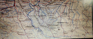
| Map of the territorial extent of Maryul or Ladakh 1100 to 1200 AD. as depicted in The History and Commercial Atlas of China, Harvard University Press. |
“The fact that the Indians had not discovered a Chinese road [in Aksai Chin] for two years seemed to suggest a tenuous claim.” Today, the US considers Aksai Chin a disputed area “administered by China but claimed by India.”

Mr. Galbraith should understand, or rather he feigns not to understand that the contention that purportedly Indians had not discovered a Chinese constructed road in Aksai Chin for two years was an all together extraneous issue which had nothing to do with the fact that the Aksai Chin has always been an integral part of India. If the Indians had not discovered a Chinese road in Aksai Chin for two years, it was because despite the fact that the accession of the princely state of Kashmir to the new Dominion of India” on October 26, 1947 "in its entirety” and the state had ipso facto become an integral part of the new Dominion of India, since India had been arbitrarily and artificially partitioned, and a huge chunk of the south western part of northwestern India had become overnight an alien country, India had been amputated of its organic part and India’s military prowess had been overwhelmingly reduced. Furthermore, the aforesaid south western chunk of territory in what was north western India newly named Pakistan had occupied a substantial portion of the state of Kashmir extending from Dafdar in the Taghdumbash Pamir to inter alia Baltistan and India
had the misfortune of having one Mr. Jawaharlal Nehru as the Prime Minister of India who was a known British loyalist and sympathiser who ran with the hare and hunted with the hounds and was veritably a wolf in sheep's clothing who did not place India first in his priorities and had ambitions to be famous as an International statesman rather than restricting his total unconditional and unflinching loyalty to his own motherland, the Republic of India. He rather than liberate the whole of the occupied part of the state from Pakistani occupation then and there, agreed to the American suggestion to give a complaint to the so-called United Nations Organisation. And after luring and instigating India to give a complaint to the United Nations Organisation rather than first liberate the occupied part of Kashmir then and there and then talk, the Americans took a neutral stance and did not support India, after India had preferred a complaint. And Kashmir became a “disputed territory” with the Pakistani occupied areas of the state continuing till date to remain under their illegal control. Thus, a militarily weak and vulnerable and amputated India had to deal with Pakistani occupation of a part of Kashmir and defend the ceasefire line running arbitrarily within Kashmir and could not enforce her sovereignty over the whole of the State of Jammu and Kashmir especially the border areas in Kashmir adjoining the Kuen Lun Range in northern Kashmir extending from the Chhogori Peak K2 to the Dafdar in the Taghdumbash Pamir and Mariom Pamir and the Raskam Tract in Kanjut adjoining the Kuen Lun Range wherein are the Kukalang, Yangi, Kilian, Sanju-la and Hindutash Passes in Kashmir. If the areas in Kashmir occupied by Pakistan had been liberated from Pakistani occupation then and there rather than giving a complaint to the bogus and spurious so-called United Nations Organisation (of which incredibly India is not a permanent member of the Security Council with full power to Veto), India could have enforced her sovereignty over the whole of Kashmir including the Kuen Lun areas of Kashmir viz. The Taghdumbash Pamir and Raskam in Kanjut, particularly Hindutash and Sanju La and the rest of Aksai Chin in northeastern Kashmir. Moreover one Mr. Jawaharlal Nehru in collusion with the Chinese had illegally arbitrarily and unilaterally abdicated and forfeited India’s precious political rights and privileges in occupied East Turkistan and Tibet which independent India had inherited after the end of British rule and betrayed Tibet and conceded to the nonexistent and fraudulent fictitious Chinese claims of sovereignty over Tibet, while not at all endeavouring to integrate all the Himalayan princely states in India extending along the main Himalayan Range continuously from Mayum-La or Marnyak La to the Lagya so as to re-establish the historic and natural continuous and uninterrupted International border of India with the Sovereign neighbouring country of Tibet from Pulu to Lagya. Mr. Jawaharlal Nehru also unilaterally and arbitrarily, unconstitutionally and illegally published in 1954, a spurious, bogus and fraudulent new so-called map of India, which is per se ab initio illegal and null and void, and ultra vires the Constitution of India and non est in law, which ceased to depict areas of the state of Jammu and Kashmir which are an integral part of the territory of India as defined in the Constitution of India which is sacrosanct, which hitherto had been depicted as integral part of India in the maps published by The Survey of India prior to 1954. So, any suggestion that India had a "tenuous claim" is perverted and deceitful and emanating from a petrified and morbid mind! So there!
 |
The Territorial Limits of the Mir of Hunza as
depicted in this Map titled Map of Sinkiang
|


