 |
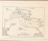
The territorial extent
of Ladakh
during the period of King Nyimagon
about 975 A. D. - 1000 A.D. as
depicted in A History of Western Tibet
by A.H. Francke, 1907
|
According to Rolf Alfred Stein, author of "Tibetan Civilization", "…Then further west, The Tibetans encountered a distinctly foreign nation. - Shangshung, with its capital at Khyunglung. Mt. Kailāśa (Tise ) and Lake Manasarovar formed part of this country., whose language
has come down to us through early documents. Though still unidentified, it seems to be Indo European. …Geographically the country was certainly open to India, both through Nepal and by way of Kashmir and Ladakh. Kailāśa is a holy place for the Indians, who make pilgrimages to it. No one knows how long they have done so, but the cult may well go back to the times when Shangshung was still independent of Tibet. How far Shangshung stretched to the north , east and west is a mystery…. We have already had an occasion to remark that Shangshung, embracing Kailāśa sacred Mount of the Hindus, may once have had a religion largely borrowed from Hinduism. The situation may even have lasted for quite a long time. In fact, about 950, the Hindu King of Kabul had a statue of Vişņu, of the Kashmiri type (with three heads), which he claimed had been given him by the king of the Bhota (Tibetans) who, in turn had obtained it from Kailāśa."
A chronicle of Ladakh compiled in the 17th century called the La dvags rgyal rabs, meaning the Royal Chronicle of the Kings of Ladakh recorded
 |
The empire of King
Tsewang Rnam Rgyal 1
and that of King Jamyang Rnam Rgyal,
about 1560 and 1600
A.D. as depicted
in A History of Western Tibet by
A.H. Francke, 1907
|
secured by that son. The following quotation is from page 94 of this book: "He gave to each of his sons a separate kingdom, viz., to the eldest Dpal-gyi-ngon, Maryul of Mnah-ris, the inhabitants using black bows; ru-thogs of the east and the Gold-mine of Hgog; nearer this way Lde-mchog-dkar-po; at the frontier ra-ba-dmar-po; Wam-le, to the top of the pass of the Yi-mig rock….." From a perusal of the aforesaid work, it is obvious and evident that Rudokh was an integral part of Ladakh, and even after the family partition, Rudokh continued to be part of Ladakh. Maryul meaning lowlands was a name given to a part of Ladakh. Even at that time, i.e. in the 10th century, Rudokh was an integral part of Ladakh and Lde-mchog-dkar-po, i.e. Demchok was also an integral part of Ladakh.
The fact that India’s
sovereignty over Minsar was recognized by Tibet is a relic of the fact that
the whole of Shang Shung or Ngari-khor-sum and Guge was per se historically a part of Ladakh
and had nothing whatsoever to do with Tibet. What is wrongly referred to as
West Tibet had nothing whatsoever to do with Tibet but had always been
historically an integral and sacred inalienable part of Maryul or Ladakh. India’s
sovereignty over Minsar was recognized in the
Peace Treaty between Ladakh and Tibet signed in Tingmosgang in 1684. The
Treaty affirmed: “The king of Ladakh reserves to himself the village of Minsar
in Ngari-khor-sum. A
report of Thrinley Shingta, the 7th Gyalwang Drukpa, head of the Drukpa
school of Tibetan Buddhism, who spent three months in the area in 1748, makes
interesting reading: “Administratively, it is established that the immediate
village of Minsar and its surrounding areas are ancient Ladakhi territory.
After Lhasa invaded Maryul or Ladakh comprising Ngari-khor-sum and Guge and
western Ladakh in 1684, it was agreed and formally inscribed in the Peace
Treaty of Tingmosgang between Tibet and Ladakh, signed in 1684, that the King
of Ladakh retained the territory of Minsar and its neighbourhood as a
territorial enclave, in order to meet the religious offering expenses of the
sacred sites by Lake Manasarovar and Mount Kailash.” John
Bray, the president of the International Association of Ladakh Studies, who
wrote about the Bhutanese and Indian (Minsar) enclaves in Tibet, noted: 'Both
sets of enclaves share a common origin in that they
date back to the period when the kings of Ladakh controlled the whole of
Western Tibet.' In the words of Claude Arpi, “It is
probably not in Indian genes to claim other nations' territory; but worse, in
some cases, India has been unable to claim its own territory”.
The capital city of Zhang Zhung was called Khyunglung (Khyunglung Ngülkhar or Khyung-lung dngul-mkhar), the "Silver Palace of Garuda", southwest of Mount Kailash (Mount Ti-se), which is identified with palaces found in the upper Sutlej Valley. The Zhang Zhung built a towering fort, Chugtso Dropo, on the shores of sacred Lake Dangra, from which they exerted military power over the surrounding district in Ladakh. The fact that some of the ancient texts describing the Zhang Zhung kingdom also claimed the Sutlej valley was Shambhala, the land of happiness (from which James Hilton possibly derived the name "Shangri La"), may have delayed their study by Western scholars. Zorawar Singh knew that eastern Ladakh comprising the Rudokh
was connected to western Tibet by the Mayum La, so his plan consisted of advancing as quickly as possible into enemy territory, capturing the pass before winter, and building up his forces for a renewed campaign in the summer.


