Thursday, August 29, 2013

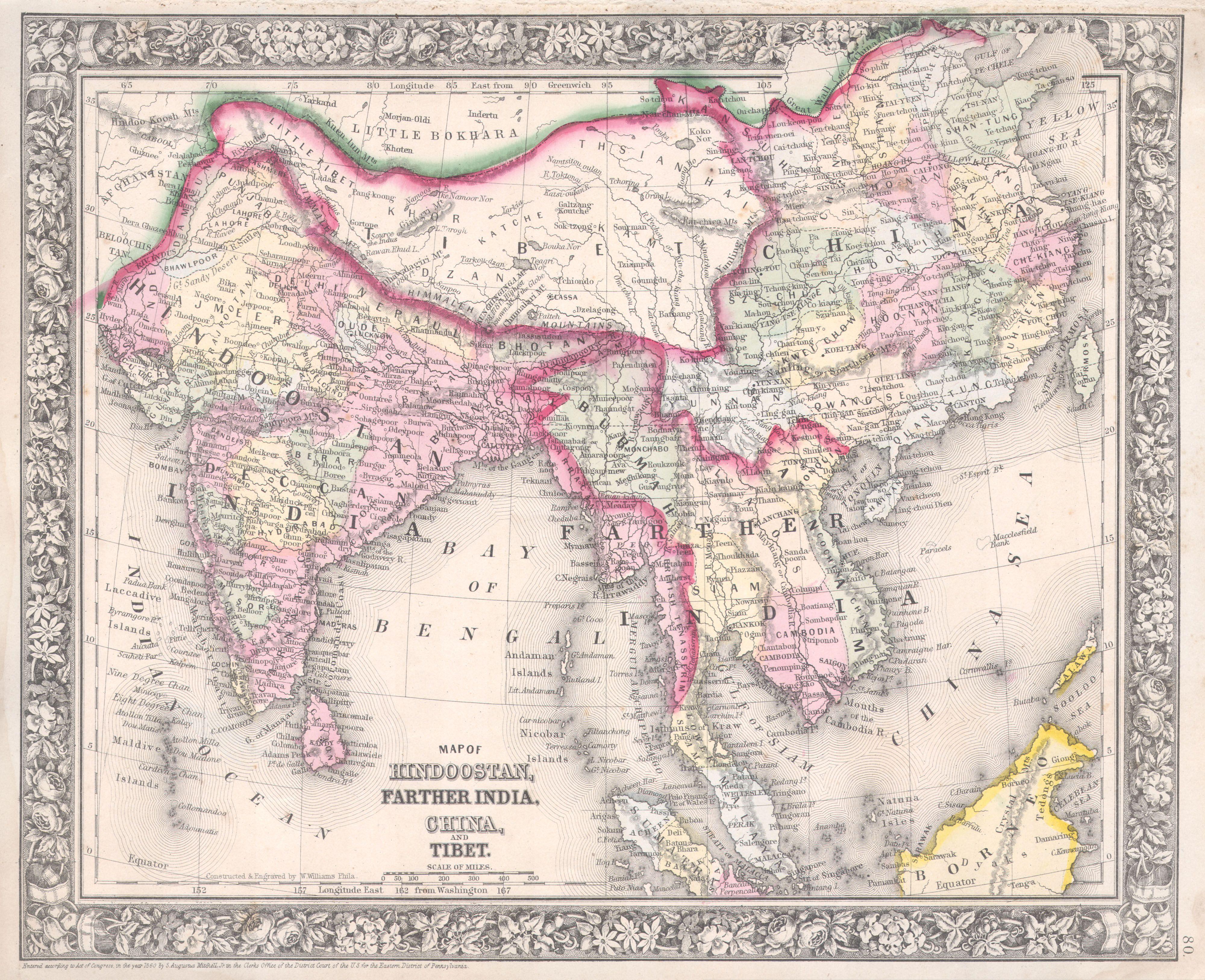
Map of India published prior to 1956

The external borders of Kashmir as depicted in this map  published in The Hindu  dated October 10, 1955 though inaccurate insofar as the fact that inter alia the northern border is not depicted on the Kuen Lun range in northern Kashmir and beyond, or the fact that the eastern frontier of Kashmir is not depicted to the east of historic area of Rudok in eastern  Ladakh, nevertheless portrays areas in Kashmir which ceased to be depicted as part of Kashmir illegally in 1954 by the Survey of India, which at the instance of Mr. Jawaharlal Nehru depicted a new spurious and bogus fraudulent map of Kashmir out of the Blue in an illegal procedure which is ultra vires the Constitution of India which is sacrosanct and supreme, and the aforesaid procedure is ab initio illegal and null and void. The areas which ceased to be depicted as part of Kashmir  had always been recognized as part of the territorial extent of Kashmir by the government of Kashmir even at the time immediately prior to the commencement of the Constitution of India as well as the Constitution of Jammu and Kashmir and had also hitherto had been depicted as integral part of India by the Survey of India in the various maps published prior to 1954 in particular inter alia the official maps attached to the White Papers published in July 1948 and February 1950 by the Government of India's Ministry of States, headed, incidentally, by Sardar Vallabhbhai Patel, under the authority of India's Surveyor General G.F.Heaney, much of which were criminally destroyed under the orders of Mr.Jawaharlal Nehru, which give them the legal status to determine the extent of the State of Kashmir as stipulated in Entry 15 in the First Schedule of the Constitution of India and the Constitution of India is sacrosanct and supreme and the spurious, bogus and fraudulent line published stealthily by Mr. Jawaharlal Nehru out of the blue in 1954 is ab initio illegal and vitiated as null and void!

In fact, the legend Kashmir is partly depicted in this map in an area which is being illegally depicted as not part of Kashmir in the bogus and spurious map published by the Survey of India criminally in 1954 at the instance Mr. Jawaharlal Nehru in a stealthy and surreptitious manner with complete impunity, which only reinforces the truth that the new 1954 map illegally published at the instance of Mr. Jawaharlal Nehru in obvious  collusion with the Chinese is blatantly illegal and an illegal cession of the territory of India in a manner not known to law did take place by this blatantly illegal act!

Monday, May 13, 2013

The perversion and deceit of the publishers of The Times Comprehensive Atlas of the World


The Times Comprehensive Atlas of the World has in several editions published a map of Afghanistan, Pakistan and north western India. In the said map,  The purported western borders of Afghanistan and Pakistan  are depicted in a cramped and congested manner and are displayed extending  beyond the regular edges of the map and the map of Kashmir is depicted in inset maps rather than as a complete and comprehensive  single map so that the viewer does not have the benefit of viewing  a complete bird's eye full view of the entire  area! The Times Atlas of The World  is a genius of such perverted deceit! The Hindutash  and the Sanju-la Passes  in north eastern Kashmir  are  not depicted as part of Kashmir though the very same Times Atlas of the World had previously depicted the  Hindutash Pass as part of Kashmir in 1900! In this 1959  map, they have the audacity to draw two lines with the caption “undefined frontier” between them but even in this 1959 map the Hindutash and Sanju-la  Passes  are  not depicted as part of Kashmir and the international border is not depicted on the Kuen Lun range in that area even as an alleged extreme view of the border not withstanding the fact that they have portrayed two lines allegedly showing the two extreme positions and the border is shown arbitrarily shifting from the Kuen lun range to the Kara Kash river after the Kukalang and Yangi Dawan passes in northern Kashmir instead of naturally continuing along the Kilian and Sanju-la  passes in northern Kashmir
and 
proceeding to the Hindutash pass in northern Kashmir in deviation of the principle involved viz the fact that historically  the territory  of  Kashmir extends to the Kuen Lun range at the edges of the highlands of Kashmir wherein are the Kukalang, Yangi, Kilian, Sanju-la and Hindutash passes in northern Kashmir,  as though there was absolutely  no legal basis, or justification or

precedents whatsoever for depicting the Sanju-la and the Hindutash Passes in northern Kashmir as part of Kashmir by
 depicting the northern  international border of Kashmir on the Kuen Lun range!  The Gazetteer of Kashmir and Ladák published in 1890 Compiled under the direction of the Quarter Master General in India in the Intelligence Branch in fact unequivocally states that Khotán is “a province in the Chinese Empire lying to the north of the Eastern Kuenlun range, which here forms the boundary of Ladák” and  “The eastern range forms the southern boundary of Khotán, and is crossed by two passes, the  Yangi or Elchi Díwan, crossed in 1865 by Johnson and the Hindútak Díwan, crossed by Robert Schlagentweit in 1857”.


So what has changed legally in the period of interregnum between 1900 and 1947 or 2013?  Was there any valid cession of territory? This, when it is the present stance of the Times Atlas of the World that the legal status of the entire territory of Jammu and Kashmir is disputed!   In this 1959 map due to their diabolical conspiracy and game plan and obvious collusion with the Chinese against India with  ulterior motives and intentions they have not shown the whole of Kashmir comprehensively as a single comprehensive map so that the viewer does not view a complete bird's eye full view of the area, but have maliciously depicted a part of Kashmir as an inset with a view to avoid displaying the area of  Hindutash in Kashmir altogether and due to this ulterior motive, they had been constrained to depict the legend  “Jammu & Kashmir”  in the area of Aksai Chin in the aforesaid  inset map. But the very same Times Atlas of the World now inter alia  in the Post 2000 A.D.  editions depict the very same  Aksai Chin area in Kashmir as either a disputed area or even allegedly  a part of “China”,  rather than depicting the area of Aksai Chin  as an integral part of Kashmir pure and simple  under blatant illegal Chinese armed military occupation. Obviously the shameless and malicious perverted publishers of the Times Atlas of the World have no morals or sense of propriety!


In the map titled “Changes of Sovereignty since World War II”, the black line depicting  “Territory ceded or Annexed  since 1939” is not shown slightly extended towards the Hindutash, Sanju –la and Kilian and the line is shown depicted along the Khunjarab and Mintaka passes deep inside Kashmir rather than  to the north of Beyik depicting the Taghdumbash Pamir and Dafdar as part of Kashmir and the border of Kashmir with the Russian Empire or Soviet Union as it was at the time of the
accession of Kashmir to the union of India and the period pertaining to the  commencement of  the Constitution of India as stipulated in Entry 15 in the First Schedule of the Constitution on India.  And in the maps titled “Physical Earth” depicting the relief maps of the various continents, the legend Sub-continent of India is conspicuous in its absence and is  nowhere to be seen extending from the Vaksh and Hindukush  to the Lakshadvipa and the Chagos archipelago. Nor is the legend Tibetan Plateau or Tibet shown extended to the Amdo and Tsaidam in north eastern Tibet though the legend British Isles is nevertheless portrayed to the West of Ireland.  
By treacherously and deceitfully not depicting the border on the  ridge wherein the Kilian, Sanju-la and Hindutash passes in Kashmir are situate, particularly when two frontier lines were depicted with the legend “undefined frontier” in between, way back in 1959, the Times Atlas has forfeited an opportunity to place on record truth pertaining to the territorial extent of Kashmir which it can never undo and for which it will never be able to make amends and compensate, and  The Times Atlas can only expect  from India eternal hatred and detest.


Tuesday, May 7, 2013

The various illegal cessions of the territory of Kashmir


The various illegal cessions of the territory of Kashmir. The Red line depicts the International border. The Green line depicts the bogus fraudulent line that was illegally drawn in 1954 at the instance of  Mr. Jawaharlal Nehru which is ab initio illegal and null and void and ultra vires the sacrosanct Constitution of India and non est in law.  The  Yellow line depicts the extent of territory in Kashmir illegally given by the Pakistanis to the Chinese in 1963, and the Grey lines depict the Ceasefire Lines or  Lines of Actual Control in the interior of Kashmir far away from the International Boundary of India.


Thursday, January 3, 2013

The editor of The Hindu does not know the meaning of tit-for-tat! Or is it convenient for him to feign ignorance?


The Chinese have depicted integral parts of India as part of China in their passports. According to The “Hindu”, “India has started stamping its map on visas issued in China in response to Chinese passports depicting Arunachal Pradesh and Aksai Chin as its territories”. Obviously, the editor of the Hindu does not know the meaning of tit-for-tat!  Or is it convenient for him to feign ignorance? If India is to respond in a tit-for-tat manner, then India should display  maps in the Indian passport which depict not just integral parts of India like inter alia  India's beloved Aksai Chin and the Assam Himalaya as part of India, but should also depict areas like Khotan situate to the north of the Hindutash and Sanju-la passes in north eastern Kashmir, and Nyenchen Thanglha or Tibet as part of India.  Only then will the response be a tit-for-tat one! If the Chinese Rogue Regime internationalises the Kashmir, India should also internationalise the disputed territories comprising Ningxia and Shanxi in the distant and extreme far northwestern frontiers of China adjoining the Republic of Mongolia and raise the issue at the International fora.

     But with the present Government of India being perverted, subservient and having the propensity to undermine the dignity and honour of India, such a response can be expected only if there is revolution which brings a sea change  in the policies of the Government.

      Look how the perverse owners of The "Hindu” have   the propensity to protect and defend the Chinese and absolve or justify the hostile actions of the Chinese against India when they state, "Beijing began issuing new electronic passports and, as per the standard practice governing all maps printed in China in recent years, it included Aksai Chin, Arunachal Pradesh ... in the map outline on the pages"!


Saturday, December 29, 2012

Jeff M. Smith, and The US position on Aksai Chin


According to Jeff M. Smith, an American scholar who has recently  published a brief account of how the Kennedy administration decided to "back" India against China on the McMahon Line, The US
Map of the territorial extent of  Maryul 
or Ladakh 1100 to 1200 AD. as depicted in 
The History and Commercial Atlas 
of China, Harvard University Press. 
position on Aksai Chin, in  the “western sector” of the so-called "Sino-Indian border" dispute, is noncommittal by comparison. At the time, John Kenneth Galbraith, America's Ambassador to India “resolved to maintain silence on the west,” concluding:

“The fact that the Indians had not discovered a Chinese road [in Aksai Chin] for two years seemed to suggest a tenuous claim.” Today, the US considers Aksai Chin a disputed area “administered by China but claimed by India.”


Mr. Galbraith should understand, or rather he feigns  not to understand  that the contention that  purportedly Indians had not discovered a Chinese constructed  road in Aksai Chin for two years was an all together extraneous issue which had nothing to do with the fact that the Aksai Chin has always been historically an integral part of India. If the Indians had not discovered a Chinese road in Aksai Chin for two years, it was because despite the fact that  the accession of the princely state of Kashmir to the new Dominion of India”  on October 26, 1947 "in its entirety” and the state had ipso facto become an integral part of the new Dominion of India, since India had been arbitrarily and artificially partitioned, and a huge chunk of the south western part of northwestern India had become overnight an alien country, India had been amputated of its organic part and rendered non-viable and  India’s military prowess had been overwhelmingly reduced as her territorial integrity and extent had been drastically reduced and compromised and India had been rendered no longer viable, and India required the help of the government of Pakistan to recover the areas of Kashmir under the military occupation of the regime in China including the Cis-Kuen Lun Tract adjoining the International boundary of India with East Turkistan on the Taghdumbash Pamir and Mariom Pamir and the Kukalang, Yangi, Kilian, Sanju-la and Hindu-tash Passes in northern Kashmir and Aksai Chin adjoining the Sanju-la and Hindu-tash Passes in Ladakh. Furthermore, the aforesaid south western chunk of territory in what was north western India newly named Pakistan had occupied a substantial portion of the state of Kashmir extending from Dafdar in the Taghdumbash Pamir to inter alia Baltistan and India
The Territorial Limits of the  Mir of Hunza as 
had the misfortune of having one Mr. Jawaharlal Nehru as the Prime Minister of India who was a known British loyalist and sympathiser  who ran with the hare and hunted with the hounds and was veritably a wolf in sheep's clothing who did not place India first in his priorities and had ambitions to be famous as an International statesman rather than restricting his total unconditional and unflinching loyalty to his own motherland, the Republic of India. He rather than liberate the whole of the occupied part of the state of Jammu and Kashmir including Baltistan, Gilgit  and Kanjut from Pakistani occupation then and there,  agreed to the American suggestion to give a complaint to the 
so-called United Nations Organisation. And after luring and instigating India to give a complaint to the United Nations Organisation rather than first liberate the occupied part of Kashmir then and there and then talk, the Americans took a neutral stance and did not support India, after India had preferred a complaint. And Kashmir became a “disputed territory” with the Pakistani occupied areas of the state continuing till date to remain under their illegal control. Thus, a militarily weak and vulnerable and amputated India had to deal with Pakistani occupation of a part of Kashmir and defend the ceasefire line running arbitrarily within Kashmir and could not enforce her sovereignty over the whole of the State of Jammu and Kashmir especially the border areas in Kashmir adjoining the Kuen Lun Range in northern Kashmir extending from the Chhogori Peak K2 to the Dafdar in the Taghdumbash Pamir and Mariom Pamir and the Raskam Tract in Kanjut adjoining the Kuen Lun Range wherein are the Kukalang, Yangi, Kilian, Sanju-la and Hindutash Passes in Kashmir. If  the areas in Kashmir  occupied by Pakistan had been liberated from Pakistani occupation then and there rather than giving a complaint to the bogus and spurious so-called United Nations Organisation (of which incredibly India is not a permanent  member of the Security Council with full power to Veto), India could have  enforced  her sovereignty over the whole of Kashmir including the Kuen Lun areas of Kashmir viz. The Taghdumbash Pamir and  Raskam in Kanjut,  particularly Hindutash and Sanju La and the  rest of Aksai Chin in northeastern Kashmir. Moreover one  Mr. Jawaharlal Nehru in collusion with the Chinese had illegally arbitrarily and unilaterally abdicated and forfeited India’s precious political  rights and privileges in occupied East Turkistan and Tibet which independent India had inherited after the end of British rule and betrayed Tibet and conceded to the nonexistent and fraudulent fictitious Chinese claims of sovereignty over Tibet, while not at all endeavouring to integrate all the Himalayan princely states in India extending  along the main Himalayan Range continuously from Mayum-La or Marnyak La to the Lagya so as to re-establish the historic and natural continuous and uninterrupted  International border of India  with the Sovereign neighbouring country of Tibet from Pulu to Lagya. Mr. Jawaharlal Nehru also unilaterally and arbitrarily, unconstitutionally and illegally   published in 1954, a spurious, bogus and fraudulent new so-called map of India, which is  per se ab initio illegal and null and void, and ultra vires the Constitution of India and non est in law, which ceased  to depict areas of the state of Jammu and Kashmir which are an integral part of the territory of India as defined in the Constitution of India which is sacrosanct, which hitherto had been depicted as integral part of India in the maps published by  The Survey of India prior to 1954.  So, any suggestion that India had a "tenuous claim" is perverted and deceitful and emanating from a petrified and morbid mind! So there!

Sunday, December 23, 2012

India should be weary of the deceit of the Government of The United States


During her visit to Guwahati last week, the US ambassador to India, Nancy Powell, reportedly said that the US acknowledges the

McMahon Line as the legitimate border between India and China
. “What matters is the context”, says C. Raja Mohan. According to him, An American scholar, Jeff M.Smith, who has recently purportedly published a brief account of how the Kennedy administration decided to back India against China on the McMahon Line, in 1962, the US Ambassador to India, John Kenneth Galbraith pressed Washington to endorse Delhi’s territorial claims on the North East Frontier Agency (NEFA), since renamed as Arunachal Pradesh. The US State Department was reluctant and instead

proposed a “study” of the issue, a classic bureaucratic device to delay and deny change! Galbraith would not give up and got President John F. Kennedy to overrule the State Department. Smith tells us that Galbraith was not convinced of India’s claims of sovereignty over Aksai Chin. Washington’s current position is that Aksai Chin is a disputed area that is claimed by India but administered by China. This policy of the United States only exposes the deceit of the United States. It wants to purportedly support India over Arunachal Pradesh only at the cost of India’s sovereignty over Aksai Chin, an integral and inalienable part of India, though there is no dearth of evidence to prove that

the Aksai Chin area has always been historically an integral part of India and the reason why in spite of all the evidence that the Chinese have not an iota of claim over the Kuen Lun border area of Kashmir, Galbraith is allegedly not convinced only proves his deceit and ulterior intentions. He is only echoing and espousing the wishes of the Chinese who want an exchange of one integral and inalienable historic part of India viz the Aksai Chin with another integral and inalienable part of India viz. the Assam Himalaya while seemingly supporting India. This is clearly not going to happen. When C. Raja Mohan says, “What matters is the context”, It can only be  this deceitful  and treacherous policy of purportedly supporting India while actually colluding with the Chinese at India's peril. And India should be vigilant and not be  fooled by the Government of the United States and should respond to such attitude with contempt. If the United States purports to support India, it should be unconditional and not piecemeal and not on a quid pro quo basis! They will have to be clear and precise as to who their friend is and who their enemy is. Pertinently, the so called McMahon Line was deliberately drawn by the English in accordance with their game plan along the foothills rather than along the watershed to deliberately give India a bad border in the north east. And the so-called McMahon Line is only an ad hoc and temporary line of control and the actual border between Tibet and India will have to be delineated and demarcated along the crests which form the water shed of the Assam Himalayas.


Yes, that's what I have been saying all along. In the long run; We don't really have any friends, only opportunistic busybodies. We are all alone and destined to be  on our own against predominantly the rest of the whole world. We have to be careful! We have to be wary of the offer of friendship from various sources. Their honesty and sincerity is suspect! In the long run we have to have an indigenously designed up to date  sophisticated star-wars defence and offense technology and intercontinental ballistic missile technologies to strike any target wheresoever anywhere, even in the western hemisphere, should any state try to endanger our peaceful existence! So that jerks who are aspiring to be President or Vice President in states wheresoever they are which are historically averse to the self-reliance of India and have game-plans put in place do not get ideas inside their morbid head!